TECHNICAL DETAILS
Difficulty
easy but with great difference in altitude
Departure point
Parking Rozes
Arrival point
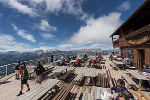
Lagazuoi refuge
Total duration
3,3 h non-stop
Path number
CAI 402, CAI 401, CAI 423
Total difference in altitude
926 m
Altitude at starting point
1820 m
Altitude at arrival
2752 m
Access
Start at the parking Rozes, under Mt. Col dei Bos, at an altitude of 1820 m. If you arrive from Cortina, the parking lot is on the right side of the Great Dolomites Road, 500 m before the parking lot of the 5 Torri chairlift.
If you look up, you can see the overhanging rocks of the Tofana di Rozes and Cordes. Above towers the summit of the imposing Tofana di Rozes, on the left the Col dei Bos.
Return
Return by cable car to the Falzarego pass (2195 m) and then you can either return to the car by bus or hike from the Falzarego pass on the trail 423 through the Ospedaletti area, with the ruins of the Italian military base at 2170 m and then walk downhill on the military road downhill to the Rozes car parking.
The distance from Falzaregopass is 5 km with a difference in altitude of 70 m of ascent and 360 m of descent
70 m, the walking time is 1,50 h.

 Fabio Bernardi